

MYRIAM CASPER

THE GREAT SOUTHERN CONTINENT

"Symmetry demanded it, the balance of the earth demanded it - for in the absence of this tremendous mass of land, what, asked Gerardus Mercator, was there to prevent the world from toppling over to destruction amidst the stars?
The Great Southern continent was to most thinkers of the time more than mere knowledge founded on discovery and experience - it was a feeling, a tradition, a logical and now even a theological necessity, a compelling and inescapable mathematical certitude. Its discovery must come."
Excerpt from the book "Wild Sea" by Joy McCann.

After 72hrs traveling South we finally reached Ushuaia, some people call this place "The End of the World".
Ushuaia is the gateway to Antarctica. To finally set foot on the continent we must sail through the "Drake Passage". Violent, chaotic, notorious and unpredictable are all words used to describe this sea passage in which over 20,000 sailors have lost their lives. It can be a true adventure because the Drake Passage can be all of the above this is when we call it the "Drake Shake" but it can also be as gentle as a lake deserving the title "Drake Lake".
It takes about 48 hours to cross the Drake Passage, depending on how furious or gentle it might be. Approximately 1,300km to reach our first destination, the Antarctic Circle, current latitude 66°33′43″ S.
I've crossed the Drake Passage to enter Antarctica seven times. Each time feels as adventurous as the first time. The sense of time abandons me and I feel life in a very different way. I could keep going back to the Land of Ice again and again.

Upon leaving Ushuaia, the wild nature is majestic and dramatic. In the sky a great variety of birds fly overhead. Albatross, Cormorant, Skuas, and Cape Petrel (aka Pintado) to name a few. I noticed "Pintados" travel alongside the ship all the way to the Antarctic Circle. I like to call them the " The Guardians of Antarctica" .
Feeling baptized after gone through the Roaring 40s, Furious 50s and Screaming 60s, the majestic ice mountains, pack ice and a variety of bergy bits now take priority of sight all over the Seascape. Antarctica residents, the wildlife, resting on the little ice islands welcomes us. Finally, I can officially say that I have arrived in Antarctica!


Over thousands of years, humans have built civilizations on every other continent on Earth. But it wasn't until the 1800s that we arrived on Antarctica. Being a spectator and witness of such grandeur has pushed me to document the beauty of such wild and pristine environment. My understanding and respect for it has grown immensely.


Icebergs have incredible stories. Once an iceberg calves off, its adventure begins. During its journey the iceberg can collide and break apart, drifting thousands of miles across the Southern Ocean. Or it could stay intact and slowly change shape as waves crashes and reshape it.

Icebergs are carried to their present location by a combination of ocean currents; the coastal countercurrent flows counter-clockwise close to Antarctica, while the powerful and largest ocean current on Earth, the Antarctic Circumpolar current, flows clockwise.
The Drake passage keeps the Icebergs from continuing counter-clockwise around the continent as the Antarctic Circumpolar squeezes through with its massive current clockwise, from that point icebergs can quickly whip north toward the equator and rapidly melt or continue spinning around the continent, sometimes for decades.
As the sailing ship slowly moved through Lemaire Channel, surrounded by the ice in all its different forms and shapes I realize how stunningly beautiful ICE is, and at this precise moment I fell in love with it.

3rd officer from the National Geographic Resolution observes the ice while crossing the Lemaire Channel. One of the most important job sailing in Antarctica is to keep watching the ice movement to avoid collision.

The Rime of the Ancient Mariner
by Samuel Taylor Coleridge
... And now there came both mist and snow,
And it grew wondrous cold;
And ice, mast-high, came floating by,
As green as emerald.
And through the drifts the snowy clifts
Did send a dismal sheen;
Nor shapes of men nor beasts we ken—
The ice was all between.
The ice was here, the ice was there,
The ice was all around;
It cracked and growled, and roared and howled,
Like noises in a swound! ...
ANTARCTICA,
the highest, coldest, windiest and driest continent of all.
A land covered by ice & surrounded by ocean. The Antarctic ice sheet covers about 98% of the Antarctic continent and is the largest single mass of ice on Earth. Glaciation began in Antarctica around 35 million yrs ago. Most icebergs have a gradual tone of blue. Older icebergs have had so much pressure over the thousand of years, that the air bubbles are all squeezed out and the light reflects blue.


In one way or another we all depend on ice to survive. Most of wildlife in Antarctica are considered to be ice dependent for food and reproduction. During summer months Humpback whales along with millions of penguins, seals, seabirds, and other whales, feed primarily on Antarctic krill. Krill eat small plants like phytoplankton. Cold, polar water and summer's many hours of daylight make the perfect breeding ground for phytoplankton as well as algae under the surface of sea ice. Parallel thought, not enough sea ice and there’s not enough food. And to add, Krill is being advertised as a power food for humans. All the above poses a major threat to the continent’s ecosystem.


Antarctica's
Wildlife
"For the animal shall not be measured by man. In a world older and more complete than ours, they move finished and complete, gifted with the extension of the senses we have lost or never attained, living by voices we shall never hear. They are not brethren, they are not underlings: they are other nations, caught with ourselves in the net of life and time, fellow prisoners of the splendour and travail of the earth.”
Henry Beston, The Outermost House 1928

The Southern Giant Petrel, known to the old sealers as "Stinkers", name that came from their habit, quite common amongst sea-birds, of vomiting on any one or thing that approached them and seemed to impose a threat. Also known as vultures of the Southern Ocean. Aggressive and opportunistic the bird annoys the Crabeater seal which was quietly resting and singing on the top of the ice, till it got pushed away and off into the water.

The wildlife in Antarctica is inquisitive and unafraid. As long as I don't get too close to them, I can spend hours observing their behaviour. Penguins move down to the sea on the so called "Penguin's Highway" to clean their plumage, which is essential for survival to keep their feathers waterproof.
Antarctica’s waters and lands are home to 235 animal species. Penguins, seals, birds, and whales are the most visible to my camera.


‘The animal—a sea leopard—sprang out of the water and came after him, bounding across the ice with the peculiar rocking-horse gait of a seal on land. The beast looked like a small dinosaur, with a long, serpentine neck.’ – Sir Ernest Shackleton
Leopard seals are incredibly solitary and have a terrible reputation. Fierce predators and formidable hunters of all the seals they do feed on warm-blooded prey, such as other seals and penguins. Although rare, there are records of adult leopard seals attacking humans, and one fatality. So far, every time I encountered a leopard seal it has been in a playful mode.


History of Whaling at Deception Island

DECEPTION ISLAND
62°57'S, 60°38'W
About 10,000 years ago there was a violent eruption that caused the summit of a volcano to collapse and form a caldera in its centre. Deception Island was born.
Since its discovery, Deception Island has played host to brutal seal and whale hunting. Several countries established research bases making an attempt to live in the caldera but nature has the last and ultimate word. Several eruptions took place expelling all human activities.
The giant rusting barrels once held thousands of gallons of whale oil, it was used to boil whale fat. Walking along the black gravel beach, you encounter a great deal of bleach out whale skeletons. Today, is more of a natural museum with the remains as a proof of its past resident's actions.
A contrasty environment with reminders of death scattered all around. The water releases magma-heated steam into the frigid air adding a sinister & chilling effect into the already melancholic mood.


Two hundred years ago, American explorer Nathaniel Palmer reported the location of Deception Island and its inner harbour to the rest of the New England fleet. The bay would prove perfect for the sailing vessels that came in search of nearby fur seal colonies. Within four years 500,000 seals were killed. Fur seal pelts were brought to China to be made into hats and ladies coats. After the seal hunt finished, the whaling activities started in 1906-1907. Approximately 150 people worked at the station during the austral summer, producing over 140,000 barrels of whale oil. Early industrial societies (between 17th – 20th century) used whale oil widely in oil lamps and to make soap and margarine, cleaning chemicals & transmission oil.


Blubber wasn't the only source of this oily bounty. Contained within the head cavities of sperm whales was an even more valuable ingredient: a clear, liquid wax that was dubbed spermaceti, which may be involved in the whale's sound production and echolocation. Whalers knew that if they could prize open the head and scoop out bucketfuls of the mysterious wax, it could fetch a much higher price than regular oil, on account of it smokeless and odourless burn. It is said that Benjamin Franklin liked to read by spermaceti candle light. The higher price of spermaceti candles made them a symbol of status for wealthier members of society, across America and Europe. Baleen was also very popular and used for buggy whips; carriage springs; corset stays; fishing poles; hoops for women’s skirts; umbrella ribs; and other applications for which plastic or steel would now be used. Ambergris, a wax-like substance found in the intestines of the sperm whale, was used as an aphrodisiac, incense and medicine in ancient times it came to be used principally in perfume manufacture because it served to impart homogeneity and permanency to different ingredients employed.


The creation and production of Kerosene, vegetable oil and hydrogenation led to refinements that eventually made whale oil a less desirable material. Hektor whaling station was abandoned in April 1931, when whale oil prices collapsed. In all, more than 2 million whales were slaughtered in the Southern Hemisphere during the 1900s.
Buildings originally designated as whalers' barracks and a laboratory, as part of the Hektor Whaling Station, later were used by the United Kingdom's Falkland Islands Dependencies Survey from 1946 until the 1960s, when they operated a scientific base there.
In 1970 Whalers Bay cemetery, considered the largest cemetery in the Antarctica Peninsula containing 35 burials and a memorial to ten men lost at sea.


Today, thanks to the eruptions, to the environmental and wildlife protections in the Southern Sea, life takes place on the island once again. Salps, eighteen species of moss and lichens that have not been recorded elsewhere in Antarctic, fur seals, several types of birds including a vast chinstrap colony, over 100,000 breeding pairs of penguins. It is a contrasty environment that works as a reminder that life and death really are next to each other.


"Deception" Island named from the fact that the "island" appears solid from the outside, until that narrow opening is found and it is discovered to be a flooded caldera. In the photo below you can see the narrow entrance called Neptune Bellows, named by America sealers prior to 1822, after the Roman sea god Neptune and the strong gusts experienced in this narrow channel. The inner coastline of Deception Island, blackened by volcanic ash with fresh snow over. Volcanic mudflow came through the centre of the house in 1970, resulting in the damage that is still visible today.


Since 1989, the Spanish Antarctic Program has done monitoring at Deception during austral summers. During the 2014-2015 survey, seismic activity was very intense. The total number of events recorded was an order of magnitude larger than in previous years, and by far the most active survey since the unrest in 1999.

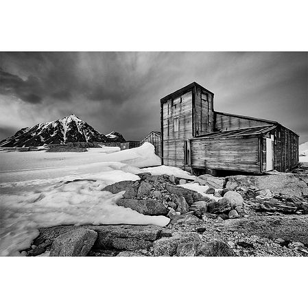
ANTARCTICA'S
Ghost Base
A visit at the abandoned stations is like stepping back in time. A perfect time capsule of the research of the time. Walking through the buildings feels as if the men have just left as some cans of food, personal belongings, and tools related to their work were left behind . It has been kept untouched since.
The history of all the stations I have visited are quite special. Here, I mention a highlight of each and at the same time something different from each other.


We visited several hauntingly abandoned sites. Some in better shape than others, but all very interesting in their unique way. A description of a daily life in one of these stations ranged from conducting meteorological studies to gathering geological data to simply mapping the area. Some of the team would travel by dogsled across the frozen sea ice between the islands and the Antarctic mainland where they would conduct their tests. In unknown terrains, crevasses were always a possibility, some were unlucky to have met one, while others were lucky to be pulled out of it. Sites had become a perfectly preserved snapshot of 1950s Antarctic life. The old typewriter was still there along with all the old log books, leftover supplies, and other everyday items that had to be left behind.


STONINGTON ISLAND a.k.a MARGUERITE BAY
There is the American Base and the British Base in the same island.
First built in 1939 by the United States Antarctic Service, East Base was commissioned by President Franklin D. Roosevelt, along with a sister base at another location. A team of researchers wintered at the base testing just about anything they could think of including seismic readings, aurora activity, tidal patterns, and the magnetic fields. Here, the first women to winter on the continent, half a century after the first men, Edith "Jackie" Ronne and a scientist, Jenny Darlington, traveled with the Ronne Antarctic Research Expedition of 1947-48, becoming the first women researchers to take part in a polar exploration. Todays women's year round presence in Antarctica is well established.
Jackie kept the expedition's log and wrote many articles for newspapers back home, documenting the discovery and mapping of the Weddell Sea coastline. She also made routine daily seismographic and tidal observations when the geophysicist was in the field.
Jennie Darlington: “I went because it was the most beautiful dangerous place in the world and because I was glad to be with my husband.” She described the journey in “My Antarctic Honeymoon,” published in 1956.

BRITISH "Station E":
Purpose: Survey, geology, meteorology and biology
Station E was established by the UK in 1946, 100m from the US East Base. The station closed in 1950 as sea ice conditions prevented access. It reopened in 1960 as the centre for field work in the south Antarctic Peninsula, and a new steel-framed, two story plywood hut was erected in 1961. The original Base ‘E’ was burnt down by accident in 1972 and only fragmentary remains mark the site. The station closed down in February 1975.

SCIENCE IN ANTARCTICA HAS GLOBAL SIGNIFICANCE FOR THE FUTURE OF OUR PLANET
People that live at the Research Stations are the only humans to reside in Antarctica. Some all year round while others, mostly scientists, spend the austral summer months studying and collecting materials that helps understand not only centuries of the history of our planet but also the future.
There are currently 75 permanent research stations scattered across the continent of Antarctica, which represent 30 countries from every continent on Earth. All told, there are as many as 45 year-round stations and 30 summer stations (field stations) while others are completely abandoned but haven’t been “cleaned up” to solidify geopolitical claims to land, fishing rights and minerals. Some nations have up to 5 research stations in the continent.
For 60 years and signed by 54 countries, The Antarctic Treaty recognizes Antarctica's unique position on the planet as a shared environment to be used for peaceful purposes and international cooperative scientific research. Together, Antarctica shall be used in the interests of all human progress and to better humankind. And hopefully stays this way, since in 2048 the treaty expires and is set for a standard review.

ORCADAS BASE
60°44′17″S 44°44′17″W
ARGENTINA - all year round
On November 2, 1902, William Speirs Bruce led an expedition to the Antarctic aboard the Scotia. They would be the first to explore the Weddell Sea and started the first permanent research station, the Omond House, on the South Orkney Island of Laurie on April 1, 1903.
Since February 22, 1904 Base Orcadas is an Argentine scientific station in Antarctica, and the oldest of the stations in Antarctica still in operation.
To this date the original Omond House remains are present on the island (photographs of rocks below).


Casa Moneta (black house), a wooden hut transported from Buenos Aires by the corvette "Uruguay" an Argentine naval vessel, was assembled at the Base Orcadas as an operational science base with accommodation in 1905. The house is named in honour of José Manuel Moneta, a leading Argentine Antarctic pioneer who wintered there four times, in 1923, 1925, 1927, and 1929. It was used as a dwelling and as an observatory, and lodged the subsequent expeditions until 1945.


In 2000, professionals of the Museo Naval de la Nación began a project to transform Moneta House into a museum, presenting it as it was in the 1920s. A historical exhibition installed to show the conditions of daily life at the oldest permanent scientific human settlement in Antarctica, with 115 years of continuous Argentine meteorological, glaciological, geodetic, and biogeographic scientific observations. Very charming!


José Manuel Moneta wrote a book "Four Antarctic Years in the South Orkney Islands" and in 1927 filmed the documentary "Entre los hielos de las islas Orcadas" ("Among the Ice of the Orkney Islands" ). I also would like to mention that one of Moneta’s hobbies was photography.


PORT LOCKROY
64º49’S, 63º30’W
United Kingdom - all year round
French explorer Jean-Baptiste Charcot discovered Port Lockroy during his 1903―1905 expedition, naming the area after the politician who helped him finance those voyages, Étienne-Auguste-Édouard Lockroy.
For more than a century Port Lockroy has been a home for explorers, whalers, scientists, and sailors who have made vital contributions to Antarctic history.
Following a conservation survey in 1994, British ‘Base A’ – Port Lockroy was recognized for its historical importance and designated as Historic Site and Monument No. 61 under the Antarctic Treaty.
Port Lockroy is located in a sheltered harbour off the coast of Wiencke Island and at the meeting of three seaways which offer some of the most dramatic mountain and glacier scenery on the west side of the Antarctic Peninsula.
Between 1911 and 1931, the harbour of Port Lockroy was used primarily for whaling. The evidence is all around. I encountered a blue whale skeleton on the shore at Port Lockroy. This skeleton is composed primarily of blue whale bones, but there are believed to be bones of other baleen whales included in the skeleton as well. Today, a colony of Gentoo penguins occupies the surrounding grounds, science work includes a wildlife study of the Gentoo penguin colony on the island. Nests are monitored, nesting pairs and chicks are counted, and they also keep track of the number of eggs.


In 1944 Port Lockroy became Britain’s first permanent Antarctic base during a World War II mission (code-named Operation Tabarin), and it remained in use as a research station until 1962. In 2006, the building was turned into a museum, post office and gift shop operated by the United Kingdom Antarctic Heritage Trust. During the austral summer there is ongoing conservation management of the site and conduct wildlife monitoring and data collection.


Walking in, the science lab and the radio room transported me to another era. The radio operator and the diesel mechanic were indispensable, as lighting and communication were essential. I observe the contrast and visualize the frustration of the radio operator, using the Morse code, trying to communicate to the outer world in the most practical way as they had a limit of 100 word to send and 200 words to receive, per month! On the other hand, the excitement of the scientists with their new findings, not only from long time ago but for the future of the planet.


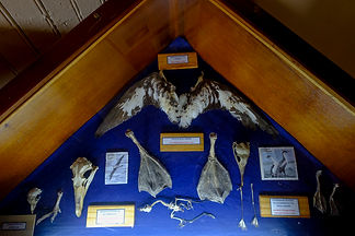
Cans of food, a collection of emptied bottles and a medicine cabinet serves as a window to look into the past and imagine how the men survived a full year in the most inhospitable place on earth.


The normal term of duty in the Antarctic was two winters which meant that men would be away from home for over 2 1/2 years. Once the ships left for the UK, the bases were completely isolated. Although irregular, visits from ships during Antarctic summer would bring mail, stores and relief personnel.


Port Lockroy is one of the most charming museum in the peninsula. There is a job opportunity which includes duties in the gift shop, share responsibility of cooking, cleaning, and general maintenance, writing statistics (temperature, wind speed/direction, precipitation) in a diary, keeping track of artifacts for the Scott Polar Institute, as well as painting and other tasks to keep the base in great shape. Science work includes a wildlife study of the Gentoo penguin colony on the island. Nests are monitored, nesting pairs and chicks are counted, and they also keep track of the number of eggs. Heads up, people living in close quarters with no running water and limited facilities are also part of the deal.

LANDSCAPE
A place of great beauty
Pristine, wild, harsh and unforgiving are words that come to my mind when describing Antarctica.
A continent that you know you are only a visitor, there is no other way. A place where it only admits intruders in for a very short period of time.
Explorers, scientists, doctors, filmmakers are some of the people that might be accepted to experience a full year in an Antarctic base.
There are moments that I feel attracted to the idea, it must be a great experience, a full year away with no way of coming back before the time completes. Away in a powerful and wild place where the coldest temperature recorded was -89.6°C and the highest wind speeds recorded was 327km/h.


Antarctica used to have a tropical climate, it cooled down slowly over many millions of years for three main reasons.
Around 30 to 50 million years ago the continent drifted south until it settled over the South Pole. Drake Passage was formed and it resulted in a major global cooling. A circumpolar current arose isolating Antarctica's weather systems from the rest of the world. And carbon dioxide levels globally fell leading to a general cooling of the planet.


The Antarctic Circumpolar Current, which swirls clockwise around the landmass, pulls up cold, nutrient-rich waters from the deep sea to the surface, a process known as upwelling. The nutrients cultivate blooms of phytoplankton and ice-algae, which feed a super-abundant supply of Antarctic krill, small shrimp-like crustaceans. Large animals, like penguins, whales, and seals all feast on the krill. During summer, October through March, Antarctica is on the side of Earth tilted toward the sun and is in constant sunlight. With abundant nutrients in the Southern Ocean and constant light during summer season, phytoplankton productivity can reach very high levels. Therefore, all Antarctic whale species migrate south during the summer months to take advantage of the nutrient rich sea.


I have an everlasting, almost impossible desire to photograph lifestyle belonging to a forgotten era. There are still some places in the world that have been kept untouched by the modern world, and that is the destination where I am ready to go, to finally satiate and feed my ravenous passion. It is one of the greatest feelings. Encountering this beautiful, traditional sailing vessel against a magnificent Antarctic glacier brought to my mind the amazing lives and stories of the greatest explorers of the 1900's.

"You don't make a photograph just with a camera. You bring to the act of photography all the pictures you have seen, the books you have read, the music you have heard, the people you have loved"- Ansel Adams
