

MYRIAM CASPER

"You can measure the depth of a person's awakening by how they serve others.” -Kūkai
Kōbō Daishi also known as Kūkai was a Japanese Buddhist monk, scholar, sculptor, calligrapher, and poet. He is widely regarded not only as the founder of one of the most influential schools of Japanese Buddhism, but also as a bodhisattva-like saviour figure still active in the world, leading beings to awakening.
Mount Kōya (高野山, Kōyasan), a 800m-deep valley surrounded by eight peaks, whose ridges resemble the petals of an eight-petaled lotus blossom was chosen by him in 816 AD as a holy site. He spent his later years there until his death in 835 C.E. According to the legend, Kūkai is not dead but remains in a state of meditation for almost 1,200 years.
Today, Kōyasan is part of the sacred pilgrimage routes known as the Kumano Kodo. For this trip we hiked along Choichi-michi & Nyonin-michi routes closer to Kōyasan then the Nakahechi Route to hit all three major Buddhist/Shinto shrines, Kumano Hongu Taisha, Kumano Hayatama Taisha and Kumano Nachi Taisha.
This page illustrates all the paths we took and the UNESCO temples and shrines we visited along them. I must say it was a very powerful journey and I hope to be back.
“You can measure the depth of a person's awakening by how they serve others.”
- Kukai

Kumano Kodo Kōyasan Chōishi-michi
高野山町石道
Kōyasan chōishi-michi is one of the seven pilgrimage routes. It begins at the Jison-in temple in the town of Kudoyama on the south bank of the Kinokawa River and extends twenty-four kilometres to Mount Kōya, or Kongōbu-ji Temple, the ecclesiastical headquarters of the Kōyasan.

K
The starting point of our pilgrimage at the foot of the mountain, we visit a temple called Jison-in, established as the gateway of Koyasan by Kobo Daishi over 1000 years ago.
Up to late 1800’s women were forbidden to enter the sacred mountain; thus, Kobo Daishi’s mother was one of Jison-in residents. According to legend Kobo Daishi came down from the mountain 9 times a month to visit his mother, that is walking the Choichi michi route, 24 km each way.


When Kobo-Daishi was searching for a location for the head temple of Shingon Buddhism, he met the god Koya Myojin in the form of a hunter in the mountains. He was led by dogs the hunter had brought with him, one black and one white. Later, he met Niu Myojin and was given Koya, the god's domain, so he could establish Koyasan.
Inspired to start our journey in this seemingly wild landscape with a lot of history and spirituality. We pass the gate, I feel I am in the right place at the right time.
As soon as I stepped in, I notice something slightly out of the ordinary, I find myself surrounded by all sizes and shapes of female breasts! Looking for an answer to my interest in knowing the story behind I meet Annen, the head of Jison-in for over 40 years.
“It all began years ago when a doctor from the nearby city of Wakayama came to pray for a patient who was undergoing treatment for breast cancer. The doctor asked to place a symbol of female breasts as an offering. Word of the unusual request began to spread and soon the temple became known as a site to pray for women's health issues. The breasts represent birth, so people use them to pray for safe pregnancies, protection from cancer and even a healthy breast milk supply," says Annen.
Jison-in is entirely dedicated to the well-being and health of women.


As we follow in the footsteps of Kōbō-Daishi, the rain pours down, I immediately thought of a Tibetan saying “The more difficult the journey, the greater the depth of purification”. In that frame of mind I notice the beauty the rain brings, a misty veil adds an incredible mood and the scent of fragrant trees plus the musky smell of earth highly magnifies my energy, everything combined makes this journey an incredible spiritual experience. It should take us about 7hours (24km at elevation gain of 1,330 m) to arrive at Daimon Gate, the main gate to Koyasan. The trail is a mixture of dirt, tree roots, stone steps, and cobble stones.

The Choishi Michi trail it's made up of 180 "choishi," or stone markers, each of which features five tiers to represent the principle elements of the esoteric Buddhist universe: Space, Wind, Fire, Water & Earth.
Stone marker number 180, at Jison-in, marks the start of the pilgrimage route. There is a stone marker every 109 meters leading to the Danjo Garan temple complex, one of the most holy sites in the center of Koyasan.

.
.

.
.

.
.


Over 80% of the markers still standing today were constructed in Japan's Kamakura period (1185-1333). In those days, Koyasan pilgrims would stop and pray at each marker as they made their way up to the mountains. Besides the stone markers, shrines and deities can be spotted along the way.
The trail is in dense forest for most of the time but now and then a panoramic view lets your sight free. The Kumano Kodo is the birthplace of the country’s spirituality. The Kumano faith is rooted in nature, forests and rocks can be inhabited by the spirits of gods (kami) and every element of nature is considered divine. Waterfalls are believed to be manifestations of Buddhist entities, making the journey through Kumano Kodo a place that brings salvation to the pilgrims. As the old saying goes, ‘Those who seek, shall find’.


After the long hike we visited Niutsuhime Shrine. Niutsuhime is the name of the local deity, and it's said that Kobo Daishi was given the land of Koyasan by Niutsuhime. Believed to be over 1700 years old, Niutsuhime Shrine is dedicated to the gods Niu Myojin and Koya Myojin.
The shrine entrance is a beautiful arched bridge. You can tell the difference between a shrine and a temple by looking at the entrance. If it has a red torii gate then it is considered a shrine, usually related to Shinto religion. Niutsuhime Shrine was registered as a World Heritage Site along with Koyasan, Kumano, and Yoshino areas as "Sacred Sites and Pilgrimage Routes in the Kii Mountain Range" in 2006. After this visit we stopped for some food and called in for the day.I felt completely transported to a different world.


Kumano Kodo - Nakahechi
The Imperial Route


A brand new day with less rain, a chance to dry my boots. The Nakahechi pilgrimage route is the one that was used by emperors and nobles from the 10th century onwards, hence its name 'the Imperial Route'. This 38km section of the Nakahechi pilgrimage route winds along forest trails and through mountain villages. The Nakahechi Takijiri-Oji and a stone signage stands at the entrance of the route. Our destination is Kumano Hongu Taisha. The stone statue of Gyuba-doji near Chikatsuyu-Oji shows Kazan, one of the first abdicated emperors to pilgrimage to Kumano, sitting on a horse and cow. The Gyuba-doji stone statue is the symbol of the Kumano Kodo.
Along side of Tsugizakura-oji gate are many gigantic Japanese Cedar trees (Cryptomeria). Some have a circumference of 8 meters and are believed to be up to 800 years old. The branches are all pointing to the south, toward Nachi Falls and the power of Kannon’s Fudaraku paradise. They are called “ipposugi”, meaning “one direction cedars”.

.
.
.


At the top of the stairs beyond the torii gate stood the Tsugizakura-Oji shrine and a pair of komainu to ward off evil spirits. One has its mouth opened and the other closed. The open mouth is pronouncing the first letter of the Sanskrit alphabet, which is pronounced "a", while the closed one is uttering the last letter, which is pronounced "um", to represent the beginning and the end of all things. Together they form the sound "Aum".
A little further the Hosshinmon-oji Shrine, “Hosshin” means “spiritual awakening” and “mon” means “gate”. Passage through this gate was a transformational rite marking initiatory death and rebirth in the Pure Land paradise.


From up the mountain a great sight of the entrance to Oyunohara, a sandbank at the confluence of the Kumano and Otonashi Rivers marked by the largest Torii shrine gate in the world (33.9 meters tall and 42 meters wide). It’s a formalized gateway that designates the entrance to a sacred area. It signifies the division of the secular and the spiritual worlds. This Torii is called Otorii, O means “big”. It was erected in the year 2000 and is made of steel.


Arrived at Kumano Hongu Taisha Grand Shrine with a beutiful sunshine. According to the Kojiki (the first documentation of Japan’s history), Jimmu, the descendent of sun goddess Amaterasu, descended from the heavens to launch a war to become the nation’s first emperor. Together with his troops, Jimmu won the war after their journey through the Kumano mountains under the tutelage of the messenger, a sacred three-legged crow named the Yatagarasu.


Kumano Hongu Taisha was originally located at Oyunohara. Legend has it that the Kumano deities, in the form of three moons, descended into the branches of a giant oak tree in this clearing. All of the Kumano Kodo pilgrimage routes lead to this sacred site. In 1889 a severe flood seriously damaged or destroyed much of the shrine and so it was relocated to its present site on the hilltop. A long flight of stairs leads up from below to the main gate. Here we go!

Otorii at Oyunohara, where Kumano Hongu Taisha Grand Shrine was located prior to the massive floods. The enormous grounds are said to have been home to 12 horizontally-arranged shrine structures. Until the Edo period, you could only enter the shrine upon cleansing yourself in the river water.


Kumano Nachi Taisha
熊野那智大社


A charming centenarian monk at the main hall of Nachisan Seiganto-ji Temple 那智山青岸渡寺. The main hall of Seiganto-ji temple was rebuilt in 1590 by orders of the warlord Toyotomi Hideyoshi, who later unified Japan. The temple worships Nyoi-rin Kannon Bosatsu, or the Goddess of Mercy. The temple’s architecture showcases the decadent style of the Azuchi-Momoyama era, around the late 16th century. Unfortunately the outside was under construction and I couldn't photograph.
An hour driving we arrive at Kumano Nachi Taisha Shrine which consists of a series of vermillion-colored buildings and torii gates set amidst grounds with superb views to Nachi Falls and the surrounding mountains. Kumano Nachi Taisha Grand Shrine enshrines the 12 deities of Kumano and the deity of Nachi Falls.
In front of the main shrine there is a stone known as the karasu-ishi, the stone of Yatagarasu, a three-legged crow and helper to the legendary first emperor of Japan, Jimmu, which is said to have been where Yatagarasu stopped to rest, after guiding God to the land of Kashihara in Nara.
To keep with the traditions, a goshuinchō (御朱印帳) “book of seals” inscribes the date and name of the shrine or temple in calligraphy along with the goshuin seal in vermilion as a proof of your pilgrimage and visit, which is one of the theories regarding its origin. During Edo period people were restricted to their villages except for the purpose of pilgrimage. Goshuin was recognized as the document of travel permission.
Video provided by Massimo Bassano, goshuinchō of Nachisan Seiganto-ji Temple.
The pagoda of Seigantoji and 'Nachi no Taki' 133 meter waterfall seen from its base. Long before the organization of religious doctrine, locals would worship the falls as the home of a spiritual deity. Later a shrine was built here, and the shrine priests serve the deity daily. This is absolutely stunning!
Details on the pagoda. The wood pieces are cut so that each one fits perfectly into slots in an adjoining piece, great for earthquakes but more susceptible for fire, like many of the temples on the pilgrimage route, burned to the ground by Oda Nobunaga during the civil wars of the 16th century. The current tower was rebuilt in 1972. The height of the pagoda is 25m.

.
.
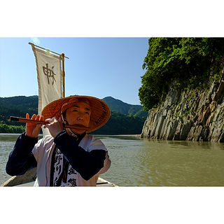
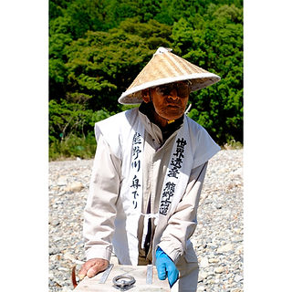

Our next visit to the Kumano Hayatama Taisha Grand Shrine we changed our way of transportation. We decided to go in the same royal manner as emperors long ago. The Kumano-gawa river is part of the Kumano Kodo pilgrimage route and is designated a UNESCO World Heritage Site. A peaceful 90 minutes magnificent experience enjoying nature at its best listening to our storyteller explaining points of interest and playing beautifully shinobue.


.
.

.
.
Shimenawa Sacred Ropes, like torii, used to demarcate the boundary between the sacred and the profane. Suspended streamers known as shide, made from washi (Japanese paper) and folded into zigzag shapes, are another common feature of shimenawa Although, also like the torii, the exact origins of the shimenawa are lost in the mists of time. There are many theories suggesting different traditions.
Kumano Hayatama Taisha Shrine is located near the mouth of the Kumano River where the water from the Kii Mountains flows in to the ocean. Over the centuries pilgrims including Emperors and Shoguns have left many offerings at the shrine and the most important are on display in the shrine's Treasure House.


Praying ritual at a Shinto Shrine: Bow Twice, Clap Twice, Bow Once.
In the grounds of the shrine, an official Natural Monument of Japan is Nagi no Ki, a sacred tree believed to be over 800 years old with the height of 17.6 m and a circumference of 5.45 m. As there is no main trunk, it is considered that some trunks gathered and formed the present shape. Ancient trees and trees with legends associated with them will be marked sacred by having a shimenawa wrapped around them.
While visiting shrines you will notice Omikuji, one of Japan’s good luck charms. Those with cursed Omikuji fortunes will tie them to these sites to leave behind the bad fortune.


Our last shrine visit in this area involves a 538 steps on a 70-degree incline staircase leading up to the spiritual sanctuary of Kamikura Shrine. At the top next to the Shrine there is a large outcropping of bare rock named Kotobiki-Iwa. According to the ancient myth, the place where the three gods of the Kumano shrines, Kumano Hayatama no Omikami, Kumano Musubi no Omikami and Ketsumi Miko Omikami, originally descended to the land. Each year on February 6th, there is an ancient festival called Oto Matsuri, a purification ritual with prayers made for a good harvest where roughly 2,000 men dressed in white race down the 538 steps with flaming torches lit from a sacred fire. Little has changed since the festival began 1,400 years ago, including the rule that women are barred from the mountain on the day. I cannot imagine racing down those steps...and I guess not in this life I will be able to photograph this event.
Before our long descend a great view over Shingu's city.

Completed. At the bottom of 538 steps! with our friend Naoki, who has been traveling and introducing Wakayama and it's wonders to us.

KOYASAN
Nyoninmichi Route


Otake-Jizo, facing the nyonindo. It was donated in 1745 by Mrs. Take Yokoyama (hence, the name of the Jizo), who used to pray for her deceased husband at this nyonindo. Most of the hike is in dense covered forest trails over tree roots, through several Torii gates and if you pay close attention some remains left over from another time.
Our last hike! Nyonin-michi Pilgrimage route known as "Women Pilgrimage Route", a 17km trail which circles along the boundaries of Kōyasan. Until 1872 women could only visit temples at the outer gates called Nyonin-do temples. Women who wanted to pay their respects to the Kobo-Daishi mausoleum established the route. Today there is only one nyonindo left at the northwestern entrance, Fudozaka-guchi Nyonindo where we started this hike towards Benten-dake peak followed by Daimon gate and finished passing Ainouraguchi into Kongō Sanmai-in. I dedicated this hike to all the women who walked along this path.


We arrived at the top. Mount Benten-dake, one of the eight peaks of the lotus petal, one of the peaks surrounding the mountaintop plateau of Kōyasan. Deity Benten's shrine was established by Kobo Daishi himself, who sought the goddess' protection for Koyasan after establishing his centre for Shingon in the ninth century. Deity Benten is the goddess of everything that flows.
There is something very romantic about going on a pilgrim's journey, especially on an area with so much history. Kumano area was, and still is, considered a place of healing; a sacred, mystical abode of the gods. I couldn't feel more inspired.


Right out of the forest my view falls on the most magnificent gate I have ever seen. The trail passes the sacred Daimon Gate, which is over 25 meters high and marks the main entrance to Koyasan. The gate, formally known as Kongōbuji Daimon (金剛峯寺 大門) was rebuilt in 1705. The spectacular bright vermilion wooden double gate is the largest in Japan.

On both sides of the entrance, two impressive Nio Statues (金剛力士像) to guard and protect the temple from evil spirits and demons. The Nio Statues were made by Buddhist sculptors Koi and Uncho during the Edo period.


.
.

.
.

.
.


We didn’t go through the gate but kept circumambulating Koyasan just as the women did in the past, and when the view allowed us to escape the dense forest and look over the sacred mountains I notice the top of Kompon Daito, the Great Pagoda and if wasn’t for the trees grown so tall I imagine the women being able to have a glimpse of what was then prohibited to them.
We decided after Ainoura-guchi to change path leaving Nyonin-michi route to visit Kongo Sanmai in, a temple complex built by Hojo Masako to pray to Buddha to repose the souls of her husband Minamoto no Yoritomo (源 頼朝) (May 9, 1147 – February 9, 1199), a Japanese warrior and clan leader and son Minamoto no Sanetomo.
Kongō pagoda of Sanmai-in, is one of the last examples of the Tahōtō style that fell into disuse after the Heian period (794-1185). Two-stories, with its lower roof curved at the ends and a pyramidal superior roof, it is entirely made of hinoki (Japanese cypress).
Kongō Sanmai-in Temple Kyozo, Scripture Repository. Like the stupa pagoda, this building was also built in the Kamakura period and is a rare example of the traditional azekurazukuri style, characterized by joined-log structures of triangular cross-section, and commonly built of cypress timbers.
Kongo-sanmai-in complex like many other temples turned into "shukubo", a Japanese word which literally means “sleeping with the monks”, in other words a lodge, providing pilgrims or travelers a place to rest and a great opportunity to experience and observe the daily life of Buddhist monks and some of the morning religious rituals.

And to finish our staying in Koyasan we spent a couple of days exploring the area and the morning rituals of monks.